11: Climate History of the Clarno Basin
Key questions for this investigation
- What evidence can be used to construct climate histories for specific locations?
- What are the strengths and limitations of each type of evidence?
- How far back in time does each type of evidence allow you to look?
Tool used in this investigation
- Biome Viewer < http://media.hhmi.org/biointeractive/biomeviewer_web/index.html > from the Biointeractive program of Howard Huges Medical Institute
Background
Paleoclimatology is the science of ancient climates. Since systematic observation of weather goes back less than two centuries, constructing a climate history for a specific place or the planet as a whole depends on using three types of data.
Instrumental – Direct observation of the weather using ground based and mobile weather stations, satellites, weather balloons, and other instrumentation. Systematic, global gathering of weather data in this way extends back less than two centuries.
Historical – Inference of past climate from historical documents such as ship logs, church records, government documents, crop records, harbor records, and other documentary evidence. This kind of data allows us to expand our view of climate almost five millennia.
Proxy – Physical evidence of past climate that includes tree rings, seafloor sediment, ice cores, cave formations, lake levels, pollen in lake sediments, corals, sedimentary rocks, and fossils. Proxy evidence enables us to see climates back hundreds of millions of years ago.
In these activities you will be looking at instrumental and proxy data to create a climate history for a unique place in north central Oregon named the Clarno Basin. The area is unique because it contains three units of the John Day National Monument, an area that contains a rich collection of evidence for nearly 50 million years of regional climate change. Additional information on the monument can be found at < https://www.nps.gov/joda/index.htm >.
Investigation
Activity A – Determining present climate of Clarno Basin
Launch Biome Viewer < http://media.hhmi.org/biointeractive/biomeviewer_web/index.html >. By default, you will be shown a rotatable globe with which you can access Climate data and biome information for major areas of the planet (see figure 1)
|
|
|
Figure 1 – Biome viewer default screen (left) and the viewer with a climate data panel for a selected location. |
|
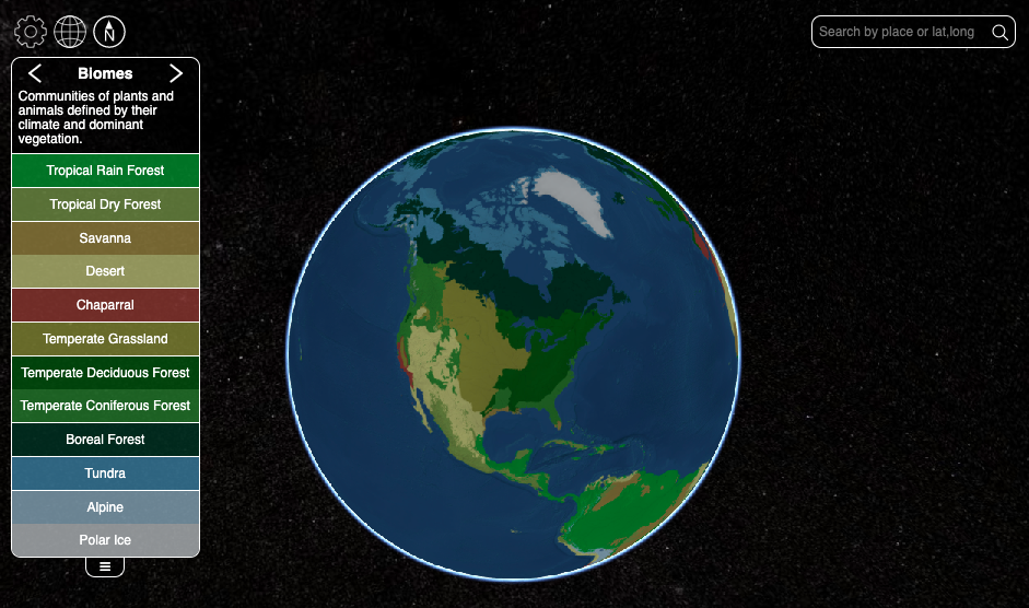
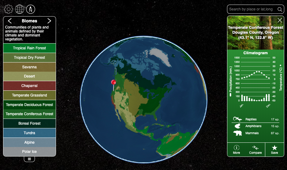
To begin this part of the activity, type “Clarno Oregon” in the search box in the upper right corner of the frame. Use the data panel that appears when you do this to address the following questions…
- What biome is Clarno in?
- What are the climate characteristics of this biome?
- What is maximum and minimum average temperature for Clarno?
- What is the average annual temperature?
- What is the maximum and minimum monthly temperature?
- What is the total annual precipitation?
- Clarno is actually located in a transitional climate that is very similar to what you get when type “Gilliam County Oregon” into the search bar. What are the characteristics of the climate for Gilliam County?
- How do the two biomes compare in terms of vegetation?
Activity B – Determining the ancient climate of the Clarno Basin
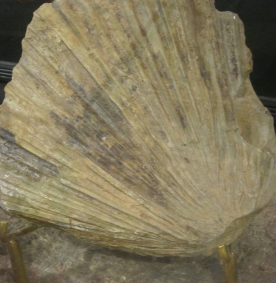
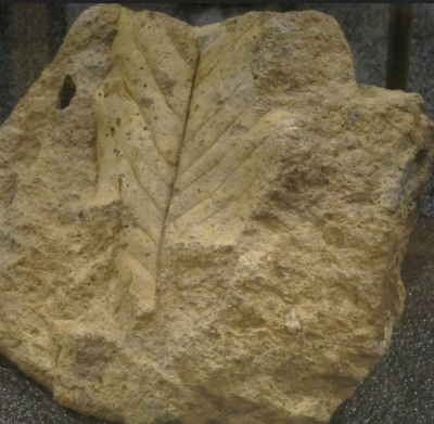
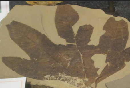
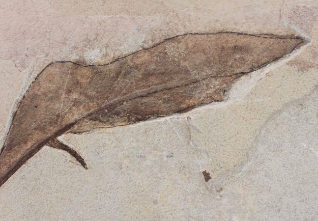
Figure 2 (see below) shows four fossil plants found in the Clarno Unit of the John Day National Monument. These fossils are preserved in a type of volcanic mudstone and are dated at between 54 and 40 million years of age. Modern day relatives of these fossils are most commonly found in semi-tropical rainforests.
|
|
|
|
Sabalies eocenica Fan Palm that is low and shrub-like. |
Magnolia |
|
|
|
|
Sycamore Leaf |
Banana Leaf |
Figure 2– Fossil plants found in the Clarno Unit of the John Day National Monument. |
|
Questions to investigate
- Provided these fossil plants were found in the same type of climate as their modern descendants, what was the climate of the Clarno Basin like 40 to 54 million years ago?
- How does this ancient climate compare to the modern-day climate of the Clarno Basin?
- Write a short climate history for the Clarno Basin beginning with its climate 40 to 54 million years ago and ending with present day. An important question to answer is what was the climate like between these two end points? Hint looking at the climates of Mexico and Central America may be helpful here.
- What kinds of proxy data could be used to confirm your climate history? To answer this, refer to the descriptions of the different types of proxy data listed on the Paleoclimatology Datasets page by the NOAA National Centers for Environmental Information < https://www.ncdc.noaa.gov/data-access/paleoclimatology-data/datasets >. When you list the types of data you could use, make sure to describe the datasets you selected and why they would be appropriate.
- What might have caused the climate changes that took place in the Basin during the past 54 million years?
- How would you test your hypothesis?
